


Mobile Topographer Free


Description de Mobile Topographer Free
Your mobile Topographer!
The leading tool for the professional surveyor or anyone who wants to mark his property, offering the best accuracy and extensive functionality that no other app can!
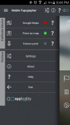
*** Increase GPS accuracy using:
- Weighted averaging (on every axis).
- Map calibration.
- Device calibration on map, or on a know point.
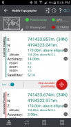
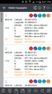
*** Display and convert GPS geodetic to Cartesian EN coordinates and back:
- UTM.
- Europe ETRS89/UTMZ28-38.
- Hellas HGRS 87 (EGSA 87).
- Hellas HGRS 87 - HEPOS.
- Hellas HTRS07/TM07.
- Iceland ISN93/Lambert 93.
- Morocco Merchich.
- SPCS83 (124 zones) USA.
- Romania S-42(58)/Stereo 70.
- Lebanon & Syria Deir ez Zor/Stereo.
- Croatia HTRS96/TM.
- Serbia SRB-ETRS89/UTM, SRB-MGI/Z7.
- Australia MGA94 (GDA94), AMG66 (AGD66) National, A.C.T., Northern Territory, NSW & Victoria, Tasmania,AMG84 (AGD84).
- Former FR of Yugoslavia MGI Balkans zones 5,6 & 7.
- Italy Monte Mario West Zone 1 Peninsular, West Zone 1 Sardinia, East Zone 2 Peninsular, East Zone 2 Sicily.
- Costa Rica CΜ05/CRTM05, Ocotepeque 1935 Costa Rica Norte & Ocotepeque 1935 Costa Rica Sur.
- Cyprus CGRS-93-LTM.
- Hungary HD72/EOV.
- Kosovo KosovaREF01.
- Latvia LKS92/TM.
- Lithuania LKS94/TM.
- Spain ED50/UTMZ29-30 NW, ED50/UTMZ29-31 ML & ED50/UTMZ31 BA.
- Uk's OSTN02/OSGM02.
- Turkey ED50/Gauss-Kruger 3° Z9-15, ITRF96 & ED50/UTMZ35-38.
- Luxembourg LUREF.
- Venezuala REGVEN/Z18-20.
- Sweden SWEREF99 TM.
- Argentina POSGAR 94 & POSGAR 2007.
- India Kalianpur 1975 ZI - ZIV.
- Algeria Nord Sahara 1959 / Z29-32.
- Armenia, Georgia, Azerbaijan, Estonia, Latvia, Lithuania, Russia - Kaliningrad and Kazakhstan Pulkovo 1942/ CS63 (A)Z1-4, (C)Z0-2, (K)Z2-4.
- Central and South America SIRGAS 2000.
- Nigeria and Cameroon Minna 1996 & 2008 MTM West, Mid, East Belts & UTM Z31-33.
- Bangladesh Gulshan 303/TM.
- France RGF93/CC42-50.
- Canada CSRS
- Egypt 1907 Blue, Red, Purple, Extended Purple belts.
- Portugal ETRS89/PTM06.
- Netherlands Amersfoort/RD new.
- Qatar QND95.
- Colombia MAGNA-SIRGAS Far West, West, Bogota, Central East, East zones.
- Mexico ITRF 2008/LCC.
- Madagascar Tananariva (Paris)/Laborde & Tananariva/UTM Z38-39S .
- Tunisia Carthage (Paris)/Mining Grid, Carthage/Nord, Carthage/Sud, Carthage/TM 11 NE, Carthage/UTM zone 32N.
- Liechtenstein CH1903/LV03C-G.
- Switzerland CH1903/LV03 (old), CH1903+/LV95 (new).
- Brazil SAD69/UTM Z18-25 & SAD69(96)/UTM Z18-25
- Spain Canary Islands REGCAN95/LAEA & REGCAN95/LCC & REGCAN95/UTM Z27-28
*** Auto stop for accurate positioning.
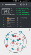
*** Examine the satellites above you in a sky view.
*** Signal strength and number of satellites indication for each GNSS constellation individually.
*** Multiple units support:
- Meters,
- International feet,
- US survey feet.
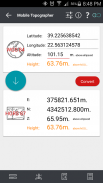
***Height calculation:
- Ellipsoidal height.
- EGM96 orthometric height calculation.
*** Convert from geodetic to Cartesian coordinates and back:
- Support for device measured points, or
- Manually input of geodetic or Cartesian coords.
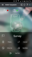
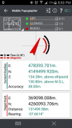
*** Drive me:
- Key in coordinates of the target point in either geodetic or Cartesian coordinates, or select a point from the list and follow the pointer.
- Compass indicating both magnetic and true North.
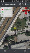
*** Project on Map:
- Project individual points on any map application.
- Project list of points, and the defined polygon, on embedded maps.
*** Save multiple point lists, to use them later.
*** Calculate area.
*** Export point lists το:
- .txt (text file)
- .csv (point file - comma separated)
- .kml (google earth file)
- .gpx (Gps Exchange format)
- .dxf (drawing file)
*** Send file via e-mail, or upload it to cloud.
*** Complete help text support.
Help us improve Mobile Topographer by e-mailing your comments and suggestions.
TAGS: Survey Surveyor Property GPS GNSS GLONASS QZSS BEIDOU GALILEO
Votre topographe mobile!
L'outil de premier plan pour l'arpenteur professionnel ou toute personne qui veut marquer sa propriété, offrant la meilleure précision et de nombreuses fonctionnalités qu'aucune autre application possible!
*** La précision du GPS Augmenter l'aide:
- Moyenne pondérée (sur chaque axe).
- Calibration de la carte.
- Étalonnage de l'appareil sur la carte, ou sur un point de savoir.
*** Affichage et convertir géodésiques GPS cartésienne FR coordonnées et retour:
- UTM.
- Europe ETRS89 / UTMZ28-38.
- Hellas SDAM 87 (EGSA 87).
- Hellas SDAM 87 - HEPOS.
- Hellas HTRS07 / TM07.
- Islande ISN93 / Lambert 93.
- Maroc Merchich.
- SPCS83 (124 zones) États-Unis.
- Roumanie S-42 (58) / Stereo 70.
- Liban et la Syrie Deir ez Zor / Stereo.
- Croatie HTRS96 / TM.
- Serbie SRB-ETRS89 / UTM, SRB-MGI / Z7.
- Australie MGA94 (GDA94), AMG66 (AGD66) National, A.C.T., Territoire du Nord, NSW & Victoria, Tasmanie, AMG84 (AGD84).
- Ancienne FR de Yougoslavie MGI Balkans zones 5,6 et 7.
- Italie Monte Mario Zone Ouest 1 Peninsular, Zone Ouest 1 Sardaigne, Zone Est 2 Peninsular, Zone Est 2 Sicile.
- Costa Rica CΜ05 / CRTM05, Ocotepeque 1935 Costa Rica Norte & Ocotepeque 1935 Costa Rica Sur.
- Chypre CGRA-93-LTM.
- Hongrie HD72 / EOV.
- KosovaREF01 Kosovo.
- Lettonie LKS92 / TM.
- Lituanie LKS94 / TM.
- Espagne ED50 / UTMZ29-30 NW, ED50 / UTMZ29-31 ML & ED50 / UTMZ31 BA.
- OSTN02 / OSGM02 Uk.
- Turquie ED50 / Gauss-Kruger 3 ° Z9-15, ITRF96 & ED50 / UTMZ35-38.
- Luxembourg LUREF.
- Venezuala REGVEN / Z18-20.
- Suède SWEREF99 TM.
- Argentine POSGAR 94 & POSGAR 2007.
- Inde Kalianpur 1975 ZI - ZIV.
- Algérie Nord Sahara 1959 / Z29-32.
- Arménie, la Géorgie, l'Azerbaïdjan, l'Estonie, la Lettonie, la Lituanie, la Russie - Kaliningrad et le Kazakhstan Pulkovo 1942 / CS63 (A) Z1-4, (C) Z0-2, (K) Z2-4.
- Amérique Centrale et du Sud SIRGAS 2000.
- Le Nigeria et le Cameroun Minna 1996 & 2008 MTM Ouest, Mid, Ceintures East & UTM Z31-33.
- Bangladesh Gulshan 303 / TM.
- France RGF93 / CC42-50.
- CSRS Canada
- Egypte 1907 Bleu, Rouge, Violet, Extended ceintures violettes.
- Portugal ETRS89 / PTM06.
- Pays-Bas Amersfoort / RD nouvelle.
- Qatar QND95.
- Colombia MAGNA-SIRGAS Far West, West, Bogota, du Centre-Est, les zones de l'Est.
- Mexique ITRF 2008 / LCC.
- Madagascar Tananariva (Paris) / Laborde & Tananariva / UTM Z38-39S.
- Tunisie Carthage (Paris) / Mines Grille, Carthage / Nord, Carthage / Sud, Carthage / TM 11 NE, Carthage / UTM zone 32N.
- Liechtenstein CH1903 / LV03C-G.
- Suisse CH1903 / MN03 (old), CH1903 + / MN95 (nouveau).
- Brésil SAD69 / UTM Z18-25 & SAD69 (96) / UTM Z18-25
- Espagne Îles Canaries REGCAN95 / LAEA & REGCAN95 / LCC & REGCAN95 / UTM Z27-28
*** Arrêt automatique pour un positionnement précis.
*** Examiner les satellites au-dessus vous dans une vue du ciel.
*** La force du signal et le nombre de satellites indication pour chaque constellation GNSS individuellement.
*** Plusieurs unités prennent en charge:
- Compteurs,
- pieds internationaux,
- Sondage US pieds.
*** Calcul de la hauteur:
- Hauteur ellipsoïdale.
- EGM96 calcul de la hauteur orthométrique.
*** Convertir géodésiques aux coordonnées cartésiennes et à l'arrière:
- Les points d'appui pour le dispositif de mesure, ou
- Manuellement entrée coords géodésiques ou cartésiennes.
*** Conduis moi:
- Entrez les coordonnées du point cible en coordonnées soit géodésiques ou cartésiennes, ou sélectionnez un point dans la liste et suivez le pointeur.
- Compass indiquant à la fois magnétique et le Nord.
*** Projet sur la carte:
- Projet de points individuels sur toute demande de carte.
- Liste des projets de points, et le polygone défini, sur des cartes intégrées.
*** Enregistrer plusieurs listes de points, pour les utiliser plus tard.
*** Zone Calculer.
*** Point d'exportation des listes το:
- .txt (Fichier texte)
- .csv (Fichier de points - séparées par des virgules)
- Kml (fichier google earth)
- GPX (Gps format Exchange)
- .dxf (Fichier de dessin)
*** Envoyer le fichier par e-mail, ou le télécharger vers le cloud.
*** Support complet de texte d'aide.
Aidez-nous à améliorer mobile Topographe par e-mailing vos commentaires et suggestions.
TAGS: Enquête sur la propriété Surveyor GPS GNSS GLONASS QZSS BEIDOU GALILEO
Mobile Topographer Free - Version 9.3.2
(22-05-2019)

Mobile Topographer Free - Information APK
Version APK: 9.3.2Package: gr.stasta.mobiletopographerAncienne Version de Mobile Topographer Free
Autres versions


Applications de même catégorie

Vous pourriez également aimer...


